![](/images/other/stat-length.png)
![Excursión Senderismo Uccle - Ukkel - GR 12 Uccle Stalle > Braine-le-Château - Photo](https://media.geolcdn.com/t/1900/400/ext.pjpeg?maxdim=2&url=https%3A%2F%2Fstatic1.geolcdn.com%2Fsiteimages%2Fupload%2Ffiles%2F1553511878bg_sport_marche.png)
GR 12 Uccle Stalle > Braine-le-Château
jojolemarcheur
Usuario
![Longitud](/images/other/stat-length.png)
Longitud
26 km
![Altitud máxima](https://static1.geolcdn.com/siteimages/upload/files/1508320355ic_sort_altitude_max_24dp.png)
Altitud máxima
143 m
![Desnivel positivo](https://static1.geolcdn.com/siteimages/upload/files/1508320355ic_sort_den_pos_24dp.png)
Desnivel positivo
507 m
![Km-Effort](/images/other/stat-length.png)
Km-Effort
33 km
![Altitud mínima](https://static1.geolcdn.com/siteimages/upload/files/1508320355ic_sort_altitude_min_24dp.png)
Altitud mínima
24 m
![Desnivel negativo](https://static1.geolcdn.com/siteimages/upload/files/1508320355ic_sort_den_neg_24dp.png)
Desnivel negativo
469 m
![Boucle](https://static1.geolcdn.com/siteimages/upload/files/16400158638029165_repeat_loop_refresh_sync_direction_icon.png)
Boucle
No
Fecha de creación :
2016-03-13 00:00:00.0
Última modificación :
2016-03-13 00:00:00.0
![Senderismo](https://static1.geolcdn.com/sitytour/trail-icons/101.png)
7h01
Dificultad : Medio
![Escanee este código QR para abrir la excursión en la aplicación SityTrail](https://capi.geolives.com/qq0zvz2zws4bq2lad0pu/sitytour/trails/537402/qr.png?size=200)
Aplicación GPS de excursión GRATIS
A propósito
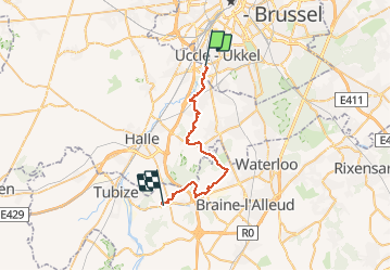
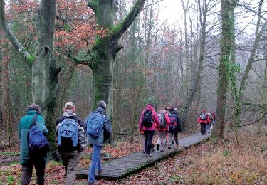
Ruta Senderismo de 26 km a descubrir en Région de Bruxelles-Capitale - Brussels Hoofdstedelijk Gewest, Desconocido, Uccle - Ukkel. Esta ruta ha sido propuesta por jojolemarcheur.
Descripción
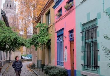
GR 12: Amsterdam > Bruxelles > Paris. Partie : Bruxelles et Wallonie.
Localización
País:
Belgium
Región :
Région de Bruxelles-Capitale - Brussels Hoofdstedelijk Gewest
Departamento/provincia :
Desconocido
Municipio :
Uccle - Ukkel
Localidad:
Uccle
Salida:(Dec)
Salida:(UTM)
592975 ; 5627820 (31U) N.
Comentarios
Excursiones cerca
![Excursión Bici de montaña Uccle - Ukkel - O2bikers_33_foret_de_Soignes - Photo](https://media.geolcdn.com/t/375/260/ext.jpg?maxdim=2&url=https%3A%2F%2Fstatic1.geolcdn.com%2Fsiteimages%2Fupload%2Ffiles%2F1524743154velo.jpg)
![Bici de montaña Bici de montaña](https://static1.geolcdn.com/sitytour/trail-icons/202.png)
O2bikers_33_foret_de_Soignes
Bici de montaña
Muy fácil
(8)
Uccle - Ukkel,
Région de Bruxelles-Capitale - Brussels Hoofdstedelijk Gewest,
Desconocido,
Belgium
![](/images/other/stat-length.png)
25 km | 30 km-effort
3h 18min
![](https://static1.geolcdn.com/siteimages/upload/files/16400158638029165_repeat_loop_refresh_sync_direction_icon.png)
Sí
![Excursión Senderismo Linkebeek - Linkebeek Perkhoeve en Peter Pan - 8 km RT - Photo](https://media.geolcdn.com/t/375/260/ext.jpg?maxdim=2&url=https%3A%2F%2Fstatic1.geolcdn.com%2Fsiteimages%2Fupload%2Ffiles%2F1553511878bg_sport_marche.png)
![Senderismo Senderismo](https://static1.geolcdn.com/sitytour/trail-icons/101.png)
Linkebeek Perkhoeve en Peter Pan - 8 km RT
Senderismo
Muy fácil
(5)
Linkebeek,
Flandes,
Brabante Flamenco,
Belgium
![](/images/other/stat-length.png)
7,6 km | 9,3 km-effort
Desconocido
![](https://static1.geolcdn.com/siteimages/upload/files/16400158638029165_repeat_loop_refresh_sync_direction_icon.png)
Sí
![Excursión Senderismo Forest - Vorst - Forest National - Uccle - Photo](https://media.geolcdn.com/t/375/260/3deb4e32-c7c7-4612-9f7e-c6f2572a529a.jpg&format=jpg&maxdim=2)
![Senderismo Senderismo](https://static1.geolcdn.com/sitytour/trail-icons/101.png)
Forest National - Uccle
Senderismo
Fácil
(1)
Forest - Vorst,
Région de Bruxelles-Capitale - Brussels Hoofdstedelijk Gewest,
Desconocido,
Belgium
![](/images/other/stat-length.png)
9,6 km | 11,6 km-effort
2h 38min
![](https://static1.geolcdn.com/siteimages/upload/files/16400158638029165_repeat_loop_refresh_sync_direction_icon.png)
Sí
![Excursión Senderismo Beersel - GG2-Bw-24_Beersel-Hennuyères_2021-11-04 - Photo](https://media.geolcdn.com/t/375/260/102ff410-776a-4c59-ae38-58c43777bc8a.jpg&format=jpg&maxdim=2)
![Senderismo Senderismo](https://static1.geolcdn.com/sitytour/trail-icons/101.png)
GG2-Bw-24_Beersel-Hennuyères_2021-11-04
Senderismo
Medio
(2)
Beersel,
Flandes,
Brabante Flamenco,
Belgium
![](/images/other/stat-length.png)
37 km | 47 km-effort
10h 44min
![](https://static1.geolcdn.com/siteimages/upload/files/16400158638029165_repeat_loop_refresh_sync_direction_icon.png)
No
![Excursión Senderismo Saint-Gilles - Sint-Gillis - RB-BX-08-Rac01 - Photo](https://media.geolcdn.com/t/375/260/ext.jpg?maxdim=2&url=https%3A%2F%2Fservices.sitytrail.com%2FGeolivesWS%2FDownloadMedia.ashx%3FTrailID%3D247898%26Media%3D4fb0a10c-9273-4113-a6c1-a6c226665b8a.jpg)
![Senderismo Senderismo](https://static1.geolcdn.com/sitytour/trail-icons/101.png)
RB-BX-08-Rac01
Senderismo
Medio
(2)
Saint-Gilles - Sint-Gillis,
Région de Bruxelles-Capitale - Brussels Hoofdstedelijk Gewest,
Desconocido,
Belgium
![](/images/other/stat-length.png)
18,8 km | 23 km-effort
5h 11min
![](https://static1.geolcdn.com/siteimages/upload/files/16400158638029165_repeat_loop_refresh_sync_direction_icon.png)
No
![Excursión Senderismo Uccle - Ukkel - RB-BX-07-Rac01 - Photo](https://media.geolcdn.com/t/375/260/ext.jpg?maxdim=2&url=https%3A%2F%2Fservices.sitytrail.com%2FGeolivesWS%2FDownloadMedia.ashx%3FTrailID%3D247895%26Media%3Df2f46971-c44e-4a53-867b-6dea0848e49c.jpg)
![Senderismo Senderismo](https://static1.geolcdn.com/sitytour/trail-icons/101.png)
RB-BX-07-Rac01
Senderismo
Fácil
(6)
Uccle - Ukkel,
Région de Bruxelles-Capitale - Brussels Hoofdstedelijk Gewest,
Desconocido,
Belgium
![](/images/other/stat-length.png)
16,9 km | 20 km-effort
4h 36min
![](https://static1.geolcdn.com/siteimages/upload/files/16400158638029165_repeat_loop_refresh_sync_direction_icon.png)
Sí
![Excursión Senderismo Uccle - Ukkel - RB-BXL-07 - Photo](https://media.geolcdn.com/t/375/260/ext.jpg?maxdim=2&url=https%3A%2F%2Fservices.sitytrail.com%2FGeolivesWS%2FDownloadMedia.ashx%3FTrailID%3D247894%26Media%3Df2f46971-c44e-4a53-867b-6dea0848e49c.jpg)
![Senderismo Senderismo](https://static1.geolcdn.com/sitytour/trail-icons/101.png)
RB-BXL-07
Senderismo
Difícil
(4)
Uccle - Ukkel,
Région de Bruxelles-Capitale - Brussels Hoofdstedelijk Gewest,
Desconocido,
Belgium
![](/images/other/stat-length.png)
26 km | 33 km-effort
7h 23min
![](https://static1.geolcdn.com/siteimages/upload/files/16400158638029165_repeat_loop_refresh_sync_direction_icon.png)
Sí
![Excursión Senderismo Anderlecht - RB-BX-05-Rac02 - Photo](https://media.geolcdn.com/t/375/260/ext.jpg?maxdim=2&url=https%3A%2F%2Fservices.sitytrail.com%2FGeolivesWS%2FDownloadMedia.ashx%3FTrailID%3D247888%26Media%3Defa9a3b4-e0b1-4a00-9376-0ef985b02cd6.jpg)
![Senderismo Senderismo](https://static1.geolcdn.com/sitytour/trail-icons/101.png)
RB-BX-05-Rac02
Senderismo
Fácil
(5)
Anderlecht,
Région de Bruxelles-Capitale - Brussels Hoofdstedelijk Gewest,
Desconocido,
Belgium
![](/images/other/stat-length.png)
14,3 km | 16,6 km-effort
3h 46min
![](https://static1.geolcdn.com/siteimages/upload/files/16400158638029165_repeat_loop_refresh_sync_direction_icon.png)
Sí
![Excursión Senderismo Anderlecht - RB-BXL-05 - Photo](https://media.geolcdn.com/t/375/260/ext.jpg?maxdim=2&url=https%3A%2F%2Fservices.sitytrail.com%2FGeolivesWS%2FDownloadMedia.ashx%3FTrailID%3D247884%26Media%3Defa9a3b4-e0b1-4a00-9376-0ef985b02cd6.jpg)
![Senderismo Senderismo](https://static1.geolcdn.com/sitytour/trail-icons/101.png)
RB-BXL-05
Senderismo
Difícil
(3)
Anderlecht,
Région de Bruxelles-Capitale - Brussels Hoofdstedelijk Gewest,
Desconocido,
Belgium
![](/images/other/stat-length.png)
23 km | 27 km-effort
6h 8min
![](https://static1.geolcdn.com/siteimages/upload/files/16400158638029165_repeat_loop_refresh_sync_direction_icon.png)
Sí